
- This website reflects our views on the Terminal 5 site based on many years of post-excavation analysis, which culminated in the publication of the final volume of the T5 report in 2010.
The Heathrow Landscape
How do we know this?
Find out more details in our archaeological evidence sectionHeathrow Airport
The Archaeologists
Framework Archaeology
Author Archives: admin
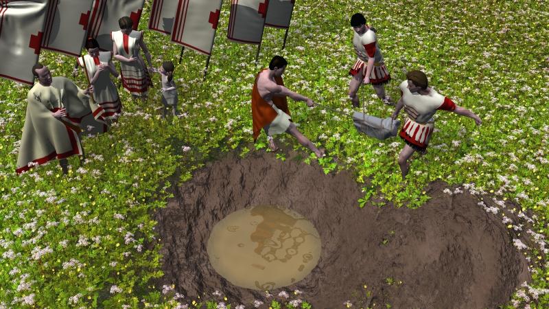
400 AD The End of an Era
A lead font is submerged in a waterhole
It cannot be demonstrated that occupation continued at Terminal 5 beyond the later 4th century AD, but it was probably at this time (c AD 400) that the inhabitants of the farmstead deposited the remains of a damaged lead tank into a waterhole on the floodplain to the west of the main settlement. The tank is one of a small group of Roman Christian lead tanks found only in Britain, possibly used for baptism or washing of the feet and indicates a small Christian population at the site. The placing of this object within a waterhole, perhaps especially dug for the occasion, is, nevertheless, part of a long-standing tradition of ritual deposition within watery contexts. It suggests that Christianity had absorbed aspects of earlier spiritual traditions, possibly helping the occupants to deal with the tumultuous shifts in the religious, political and social circumstances of the final days of the Roman Empire in Britain.
2400-1700 BC Bronze Age Enclosure
A view of the Bronze Age enlosed landscape.
Despite the landscape now being divided by hedges and track ways, people and their animals still needed access to water. Access to streams and rivers had been made more difficult by the hedges and so people dug large, deep water holes near their settlements and in their fields to provide this vital recourse in each of the landholdings.
While waterholes had an obvious but important practical function for Bronze Age farmers, archaeologists have suggested that watery places often held special significance for our ancestors. These waterholes may have acted as a focus for people to come together from different family groups in the landholdings to undertake ceremonies that reminded them of their past and how they had been and still were linked together to form a community. We think that as part of these ceremonies unusual artefacts such as wooden axe hafts and wooden ards (used for cultivating the soil) were placed in the waterholes. In one case a stone axe head that was already 1500 years old and probably a very important family heirloom was also placed in the waterhole. These ceremonies were an important way of maintaining the links between the family groups and reminding everyone that although they were now psychically separated by ditches and banks they still formed a community.
.
1,700-700 BC Dividing the Landscape

Bronze Age settlement construction within the landscape.
Between 2,000 and 1,700 BC the centuries-old mechanisms for controlling land access and tenure were breaking down, though we don’t know why. It could have been due to population growth or any number of unrelated factors.
The new solution adopted by the community and families at this time was to divide the landscape up with ditches and banks topped by hedges into distinct ‘farmsteads’. To allow these fields to be laid out we know that the landscape had been largely cleared of woodland. It would appear that each family group lived and farmed in scattered settlements within their respective farmsteads, which were further subdivided into small fields.
Over time the boundaries between the farmsteads developed into trackways or lanes used to move animals around the landscape. Pollen and plant evidence from waterholes show that people were keeping sheep and cattle in the fields and also growing cereals. If we were able to go back in time and visit Heathrow around 1,500 BC we would see a landscape of small settlements, fields and trackways. This is the origin of the sort of rural English landscape that we would be familiar with today
Posted in The Enclosed Landscape
Leave a comment
Bronze Age water hole animation
![]() Download an animation showing a water hole of Bronze Age date (requires QuickTime).
Download an animation showing a water hole of Bronze Age date (requires QuickTime).
©BAA 2003
Produced by Marshall Lightfoot plc
Reproduced by kind permission BAA
700-100 BC The Community Reunites
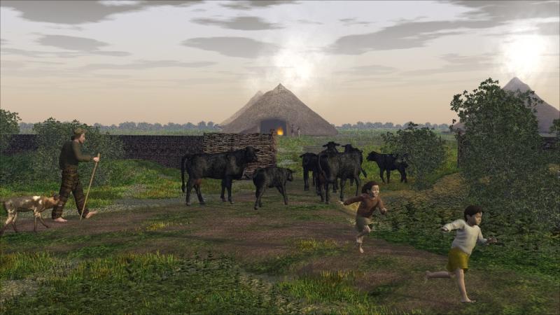
A farmer herds his cows into the settlement, with roundhouses in the background
From at least 700 BC (and probably from as early as 1,000 BC) the dispersed settlements of the family groups of the Middle Bronze Age gave way to a single large settlement occupied by a reunited community. This settlement was constructed in the middle of the site. Although this required some of the hedgerows in the vicinity to be uprooted, the majority of the fields that had been established over 1,000 years earlier continued in use. Our evidence for this settlement is clearest from about 400 BC during the Middle Iron Age when it consists of at least 14 roundhouses with thatched roofs and wattle and daub walls. The community in the settlement now farmed the previously independent farmsteads of the Middle Bronze Age as a single agricultural resource. This included the creation of a vast enclosure, which may well have provided a protective pasture for collective herds of cattle, sheep or horses. Animal rearing and cereal growing were still the main sources of food for the people of the settlement, with the greater emphasis being on the pastoral resource.
Posted in The Enclosed Landscape
Tagged community, iron-age, middle-iron-age, roundhouses, settlement
Leave a comment
Iron Age settlement animation
![]() Download an animation showing the Iron Age settlement (requires QuickTime).
Download an animation showing the Iron Age settlement (requires QuickTime).
©BAA 2003
Produced by Marshall Lightfoot plc
Reproduced by kind permission BAA
Framework Freeviewer available
The Framework freeviewer is now available for download via The Evidence page.
Posted in Uncategorized
Leave a comment
The Pre-Monumental Landscape
We know that people were moving across the Heathrow landscape as long ago as 500,000 BC, the Palaeolithic period, but the evidence for this is amounts to only a handful of worked flints, a battered hand-axe and the bone of a bison preserved in an ancient river channel. By the 7th millennium BC the body of archaeological evidence has grown and we see a Mesolithic woodland landscape interrupted by occasional clearings.
Scatters of struck flints offer the main evidence for Mesolithic activity but we know that sometime during the seventh millennium BC groups of people gathered in a clearing alongside a small stream that flowed across the T5 site. Here they dug a cluster of shallow pits and deposited within them burnt stone and flints, flint tools, animal bones and plants and fruits. This activity may have marked the final act of ceremonies that brought families together to negotiate agreement over rights of way in the landscape, which provided access to the resources essential to everyday survival. The rituals also ensured that the meeting places took on a special meaning in the lives and memories of the inhabitants, giving the location an enduring significance.
Posted in The Pre-Monumental Landscape
Leave a comment
A Monumental Landscape
Explore the Monumental Landscape
From the fifth millenium BC onwards our picture of human habitation changes. Flint tools are more common and pottery vessels make their first appearance. The vast tracts of woodland that covered the site were gradually cleared and controlled. A new architecture appeared in the landscape, with monuments constructed at important locations between the period 3,600 and 1,600 BC. These include the Stanwell Cursus, a linear construction of double ditches with a central bank that stretched for almost four kilometres. This massive monument sealed the ancient site of the Mesolithic pits. The Stanwell Cursus may have been a processional route for special ceremonies and may have also served as a barrier that divided the river floodplain from the upper gravel terraces. Whatever its function, the monument brought together the inhabitants of the Neolithic landscape, both as a building project and as a venue for communal activity in a place of ancient significance.
Smaller monuments, some linear, others designed as small, less visible enclosed spaces, were constructed during the Neolithic. These also were used for communal ceremonies, probably associated with solar events, such as the mid summer and mid winter solstices. The ceremonies would have brought family groups together as communities to negotiate ownership of land and the resources of a landscape which, by now was being tamed and divided. But these ceremonies were conducted by a small elite within the secret, sacred spaces of small enclosures, hidden from general view by high internal banks. Later in the Neolithic, the locations of these by now decaying monuments were used as venues for activities which left less obvious traces in the landscape. In this later period pits were dug and filled with pottery, flints and food during ceremonies that sealed agreements between the inhabitants and marked the importance of the place.
Posted in The Monumental Landscape
Leave a comment
8,500-4,000 BC Deep Forest and a River

Mesolithic activity adjacent to a silted up stream channel in a forest clearing.
Mesolithic location
Between the end of the last Ice Age at 9,000 BC and the introduction of agriculture at around 4,000 BC, the inhabitants of the Heathrow landscape lived a mobile life, existing by hunting animals and gathering wild plants. The landscape for much of this period would have been heavily wooded, and it is likely that people lived in small family groups. From time to time during the year, these families would have met to exchange news, celebrate marriages and commemorate deaths. Negotiating agreements about access to the resources of the woodland and the Colne floodplain would have been an important element of these meetings.
We believe that a cluster of shallow pits containing burnt flint dated to the 8th to 6th millennia BC marks the location of one of these meeting places on the gravel terrace. The pits are located adjacent to a silted-up stream channel, a boggy area devoid of trees which formed a small, natural clearing in the forest canopy. We do not know exactly what activities led to the digging of the pits, but the burnt flints found in them suggest they may have been used for boiling meat for communal feasting. The waste bone and burnt flint from repeated visits would have accumulated to form a low rubbish mound or midden over time, lending the location an important historical meaning for the family groups who met there.
When we come to consider the construction of the Stanwell cursus in the fourth millennium BC, we will see that it incorporated the location of the Mesolithic burnt flint pits, and discover how the residual meaning attached to that location was transformed into something new.
In addition to the burnt flint pits on the gravel terrace were a group of stakeholes found at Bedfont Court on the river Colne floodplain, dated to c 6,000 BC, indicating that Mesolithic activity was widespread across a range of local environments.